Tag Archives: wet woodland

Swans on The Liffey In Newbridge

For many years now we have been graced by the appearance of Swans on the Liffey in Newbridge, and it brought to mind the story of The Children of Lír which as I remember goes thus:

Swans In Flight Heading Up River on the Liffey

King Lír (who was “Lord of the Sea”) married Eva and they had four children, the first born were Aodh and Fionnula, later two more sons were born to Eva, Fiachra and Conn. Eva died soon after the birth of Fiachra and Conn, and sometime later Lír married again this time to Aoife, who may (or may not) have been Eva’s sister.

Swans Heading Up-River

Soon Aoife became jealous of the obvious love Lír had for his four children, and began to plot how to get rid of the children. No-one was willing to kill the children on her behalf, and she could not bring herself to kill the children. So, in time she brought them to a nearby lake, and encouraged them to swim in the waters, but as soon as the four children were in the lake she used her magic to transform the four children into Swans. She cursed them to roam the lakes and rivers of Ireland for 900 years – the first three hundred years would be spent on Lough Derravaragh (in modern day Westmeath), three hundred more on the Straits of Moyle (which run between Antrim and Scotland), and finally three hundred years on Atlantic coast island of Inishglora.

Swans on the River Liffey

Soon Lír went in search of his missing children, and came across the lake where four swans were singing mournfully – happily the Swans retained the ability to speak in human voices. Lír soon realised that these were his children, and they explained how they had been bewitched and changed from human form to Swans by their step-mother. When Lír realised that his children would live as Swans for 900 years, he himself cast a spell on Aoife transforming her and banished her into the eternal mist.

Swans on the Liffey
Swans on the Liffey

Lír visited his children every day, until they had to leave for Straits of Moyle where they suffered greatly due to the stormy weather in this area. However, another 300 years passed and they flew onwards for the lake on the island of Inishglora. By this time St. Patrick had come to Ireland.

Swans on the Liffey
Swans on the Liffey

Towards the end of their 900-year odyssey, it was on Inishglora they first heard a bell, and they followed the sound and were housed and protected by a Christian monk or Holy Man.

Swans on the Liffey
Swans on the Liffey

However one day the King of Connaught reached the island, as he wanted to capture the Swans as a wedding gift for his new wife, when he tried to take them from their new home, the bell sounded again and the four swans were returned to human form – first as young children, though they aged rapidly. The monk knowing that they were soon to die, baptised them, and buried them together nearby.

Swan On the Liffey
Swan On the Liffey

According to the Birdwatch Ireland Website there are three naturally occurring Swans in Ireland, and these are The Mute Swan, The Whooper Swan and Bewick’s Swan.

Swan On the Liffey
Swan On the Liffey

The Mute Swan (Eala bhalbh, Cygnus olor) is commonly seen in Ireland on lakes and rivers, they eat mainly water plants which they can easily reach with their long necks. A likely breeding site would be on the Wet Woodland island south of the bridge

The Whooper Swan (Eala Ghlaoch, Cygnus Cygnus) is a winter visitor (from Iceland) to wetlands eats mainly water plants, but can also be seen “grazing” on grass, stubble grain or even potatoes! Identified by a yellow and black bill, with the yellow projecting below the nostril.

Bewick’s Swan (Eala Berwick, Cygnus columbianus) are less common, again a winter visitor (from Siberia) and the smallest of the three swans most commonly seen in Ireland. Has a shorter neck, and a yellow and black bill. Mainly eats tubers, shoots & leaves.

I have noticed recently that many of the Swans are “ringed” which is a good development as they are being monitored. There are Swans also on the Lake in Pollardstown Fen.

Cosantóir Yarn Bombed in the Liffey Linear Park

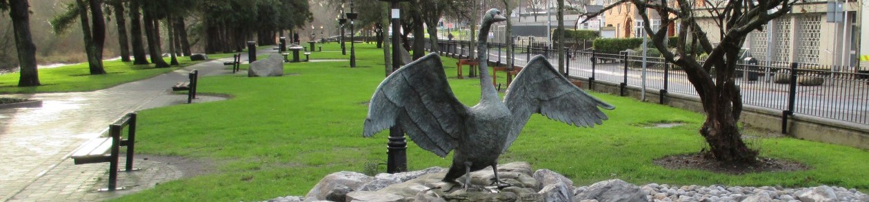
Many countries have old traditions, stories or myth involving a “wicked” stepmother, as in the fairy tales of Snow White and Cinderella. This story of The Children of Lír, may be one of the reasons that here in Ireland we are protective of swans. There is a sculpture of a Swan – Cosantóir (protector) at the entrance to the Liffey Linear Park here in Newbridge.

Interestingly Queen Elizabeth has a prerogative over all swans in England and Wales, and here in Ireland they are a protected species.

The lyrics below are taken from The Centenary Commemorative Edition of Moore’s Irish Melodies, (with Symphonies and Accompaniments by Sir. John Stevenson and Sir. Henry Bishop) – originally published 1858, a rather large book containing words and sheet music for many of Thomas Moore’s best loved compositions. Moore lived from 28 May 1779 to 26 February 1852. The book has come down in our family from my grandmother who played the violin.

The Song of Fionnuala

(Silent, O Moyle! be the roar of thy water)

Ι

Silent, O Moyle! be the roar of thy water,

Break not, ye breezes, your chain of repose,

While, murmuring mournfully, Lir’s lonely daughter,

Tells to the night-star her tale of woes.

When shall the swan, her death-note singing,

Sleep, with wings in darkness furl’d?

When will Heav’n, its sweet bell ringing,

Call my spirit from this stormy world?

Ι Ι

Sadly, O Moyle! to thy winter-wave weeping,

Fate bids me languish long ages away;

Yet still in her darkness doth Erin lie sleeping,

Still doth the pure light its dawning delay.

When will that day-star, mildly springing,

Warm our isle with peace and love?

When will Heaven, its sweet bell ringing,

Call my spirit to the fields above?

Moores Irish Melodies, A Treasure Trove of Old Irish Airs

A Special Riparian Habitat on your doorstep

Most people locally will be aware of the Curragh – a fairly unique and diverse habitat of grassland & gorse/heather, there are mature woodlands and individual trees at Great Connell, Old Connell, Moorefield Park, Morristown Biller and other areas in the town, and of course the Fen at Pollardstown – a spring fed post-glacial habitat formed over 10,000 years ago supporting many unique examples of flora and fauna.

In addition to these “natural” areas, there are a number of managed public open spaces (such as the Liffey Linear Park, the public open spaces at Lakeside / Dara Park, Moorefield Park etc.), and indeed many residential areas have substantial green areas which are of benefit to the community.

Happily some of the older hedgerows on approaches to the town have also survived – these hedgerows provide corridors which connect wildlife and plants in different areas of the town and its environs to each other and indeed to the River Liffey. Hopefully these hedgerows will survive as the town develops further and expands outside its current developed areas.

The Island viewed from St. Conleth’s Bridge
The Island viewed from St. Conleth’s Bridge, Newbridge
The Island viewed from the Watering Gates
The Island viewed from the Watering Gates in Newbridge

We are lucky to have the River Liffey flowing through the town, the Liffey and its environs are of significant ecological importance to Newbridge – not to mention its importance to other settlements along the river. Strangely the Local Area Plan (2013/2019) does not designate the Liffey “for nature conservation – as it flows through the town” of Newbridge (Ref. #1).

The Local Area Plan does however identify an ecologically important habitat which they define as “a pocket of wet woodland (WN6) on the island in the river upstream of St. Conleth’s Bridge”. (Ref. #1)

Fallen Trees - Left to Nature or Management Needed.
Fallen Trees – Left to Nature or Management Needed, Newbridge

This “island” which runs from St. Conleth’s Bridge, along the side of the Patrician Monastery grounds, across the end of Chapel Lane and along to River Court residential estate is defined as “a rare habitat within the Newbridge study area and in the surrounding localised area generally and principally supports willows (sally and white willow), with ash, alder, elm and beech also noted.” (Ref. #1)

Most of the wetlands we generally encounter are swamps, marshes, fens such as Pollardstown and bogs such as our own Bog of Allen. However you could probably define a Riparian Wetland as a vegetated area along (or within) a river such as Liffey, where the land area is subject to periodic or reasonably frequent flooding, but where the land area could also support trees, vegetation and wildlife which can thrive in saturated soil conditions.

The Liffey is flooded in a controlled manner by the ESB who release water from Golden Falls near Poulaphouca Lake to generate Hydro Electricity – usually this water is released three times daily, and this flood generally reaches Newbridge approximately six hours later. This release of water ensures that the island in Newbridge is subjected to regular flooding.

A number of years ago, the Tidy Towns Association erected bird nesting boxes in this area, and a survey carried out two years later indicated that upwards of 60% of the boxes had been occupied.

Bird Boxes Erected on the Island in 2010
Bird Boxes Erected on the Island in Newbridge (2010)

Back in 2009 the channel between the island and the Patrician Monastery had become totally overgrown and blocked by fallen trees and assorted debris. This debris was cleared thus re-opening the channel and allowing the Liffey water to circulate around the island again, and as a consequence the island is now only accessible by crossing the river itself. This work also uncovered / exposed the wall which runs along the side of the river on the Monastery side.

Clearing Debris from the Island Channel

There is also a wall on the opposite side of the river which stretches from the “Watering Gates” to the “Strand” – I estimate that this wall was built sometime between 1859 and 1871 as the Watering Gates are not clearly defined on the 1859 map, but are obvious on the 1871 map. Happily the local area plan details a Green Infrastructure Policies and Objective GI 6: which states that it is Council objective “To ensure old stone walls are protected where appropriate and the contribution they make to green infrastructure is protected”. (Ref. #2)

The island itself did not exist in photographs which the author has seen dated 1906 (Lawrence) or 1915 (Eason) although the developing mud and sand banks are visible in maps from the late 1800’s, and on studying the location of these mud and sand banks they were clearly the origins of the current island on the Liffey.

A View of the Island on the Liffey @ Newbridge

The importance of preserving this riparian wetland cannot be overemphasised, left alone to nature is one option; however some management may be required to enhance the existing wetland and ensure it continues to be a resource for Newbridge and its wildlife. Management may include monitoring the area to prevent the spread of invasive species, re-planting fallen trees with native species thus ensuring biodiversity conservation (or even enhancement).

(Ref. #1) Kildare County Council. (2013). Habitat Mapping and Green Infrastructure. Newbridge Local Area Plan. 2013/2019 (7.11.6), p106. Available at: http://kildare.ie/CountyCouncil/Planning/DevelopmentPlans/LocalAreaPlans/NewbridgeLAP2013-2019/Newbridge%20Local%20Area%20Plan%202013-2019.pdf. (Last accessed 15th March 2015).

(Ref. #2) Kildare County Council. (2013). Habitat Mapping and Green Infrastructure. Newbridge Local Area Plan. 2013/2019 (7.11.6), p108. Available at: http://kildare.ie/CountyCouncil/Planning/DevelopmentPlans/LocalAreaPlans/NewbridgeLAP2013-2019/Newbridge%20Local%20Area%20Plan%202013-2019.pdf. (Last accessed 15th March 2015).

Photographs © dwdepaor

Newbridge / Droichead Nua 1933 – From the Air

Newbridge from The Air 1933

“An Droichead Nua”, which is the official name of the town since the 1930’s, and means simply “The New Bridge”. The parish of Newbridge was made up of six ancient parishes and portions of others; these are Ballymany, Carnalway, Great Connell, Killashee, Morristown Biller and Old Connell.

How small and compact Newbridge was back then – you can see how the town has changed in the short period since 1933 – these photographs were taken in the same year as Eric Rigby-Jones founded Irish Ropes and commencing rope manufacturing in what was then the former Riding School building within the abandoned military barracks. Rigby Jones’s decision to locate his rope manufacturing factory in Newbridge led to the resurgence of Newbridge, provided employment and reinvigorated commercial activity in the town. This was soon followed by the establishment of Newbridge Silverware (then Newbridge Cutlery) in 1935, and with employment generated by the Military in the nearby Curragh Camp, and the Horse Racing industry which developed on the outskirts of the town.

Some of you may have seen these photos before, however they are an interesting record of Newbridge back in 1933.

Newbridge in 1933 looking over the Liffey

Looking at Newbridge over the Liffey, local people will note that the Gasworks (now gone) is prominent; the “Watering Gates” are evident, as is the Parish Church, as are Main Street, Eyre Street and part of the barracks accommodation block. I understand that the first bridge in Newbridge was constructed circa 1656 at the site of present “Watering Gates”, the bridge in this photo is the previous five arched bridge which was replaced just three years later in 1936.

Missing are Dominick’s Park, College Park, Páirc Mhuire, River Court, Liffey Drive, Connell Drive, the current Patrician Monastery the Riverbank / Library building….and many more of our current landmarks and residential areas.

The floodplain area beside the Liffey at the end of Chapel Lane – upstream of St. Conleth’s Bridge has since developed into an island – and is now a protected pocket of wet woodland (WN6) which is deemed to be an “ecologically important habitat”.

Newbridge in 1933 looking over the Barracks

 Looking at Newbridge over the Barracks you will notice that almost all the buildings are now demolished…the Bord na Móna building remains from this period as does the Town Hall. The Courthouse (now demolished) is visible at the end of Georges Street / Market Square, Charlotte Street / Station Road are evident. A fledgling Cutlery Road is just visible as a track on the left side of the photo.

Building of the Barracks commenced in 1813 and it was completed sometime in 1816, this photograph gives some indication of the significant size extending from the site of the present Whitewater Shopping Complex, down through the present Bord na Mona site, St. Conleth’s GAA Grounds to the present Garda Station. The barracks extended from Main Street back to Military Road where some (limited) remnants of the barrack wall, gates, and fortifications remain.

The barrack was occupied by the British Army until 1922 when following the Anglo-Irish Treaty the British Army evacuated the barracks in Newbridge. The barrack was used as an internment camp by the national army during the Civil War; however the barracks was not required as a Military Barracks by the new Irish Army, and was closed following the Civil War. The then Town Commissioners, realising that the then population of 3,000 was in the main relying on the barracks for trade and work petitioned the new Irish government for help with little or no success – however as noted above that was all to change in 1933.

St. Conleth’s GAA (County Grounds) has been laid out on what was I understand the former Cricket field within the Barracks.

Sources / Acknowledgements:

Thanks to a tip-off from Andrew Doherty http://russianside.blogspot.ie/ I found a photographic site titled “Britain from Above” which hosts old photographs – including some of Ireland, and found the above two photos of Newbridge….worth a look folks search your townland or area….it might be there http://www.britainfromabove.org.uk/

Photographs ©English Heritage and used with permission:

“Newbridge in 1933 looking over the Liffey”
http://www.britainfromabove.org.uk/download/XPW042348
“Newbridge in 1933 looking over the Barracks”
http://www.britainfromabove.org.uk/download/XPW042349

The River Liffey – An Life

Liffey Linear Park @ Newbridge

The River Liffey has played a central role in the development of Droichead Nua / Newbridge, indeed it can be argued that the reason for the original settlement in the area at Great Connell (Great Connell Abbey & Connell Ford), and the subsequent development of the town originally as a (mounted cavalry) military base for the British Army (commenced 1813) was due to its location beside the River Liffey.

The area where the ancient Connell Ford existed at Walshestown Cross, Newbridge.
The area near where the ancient Connell Ford existed at Walshestown Cross, Newbridge.

The River Liffey which rises in the Wicklow Mountains flows through Counties Wicklow, Kildare and Dublin, entering the Irish Sea at Dublin Bay. County Kildare is host to the river waters for most of its 132 km length. The major towns on the Liffey are – Ballymore Eustace, Kilcullen, Athgarvan, Newbridge, Caragh, Clane, Celbridge, Leixlip, Lucan and Dublin.

Remaining Ruins of Great Connell Priory Founded 1202, Suppressed 1541.  (Before the clean-up in 2012)
Remaining Ruins of Great Connell Priory Founded 1202, Suppressed 1541.    (Before the clean-up in 2012)

Ultimately there is a responsibility on each of the Local Authorities in Wicklow, Kildare and Dublin to protect the River Liffey from development, encroachment and pollution. As the longest area of the Liffey flows through County Kildare if falls on Kildare County Council in particular, and indeed on its Elected Members to protect the riverbanks from excessive development and encroachment. In that regard the Local Area Plan for Newbridge which was adopted by the Council in December 2013 outlines its strategy in section 2.2 Liffey Valley Park, Newbridge (2011):-

The purpose of this Strategy is to develop a linear park through Newbridge with objectives already contained in the Kildare County Development Plan 2011–2017 and previous plans. Specific objectives have been identified for lands adjoining the Liffey including the linkage of existing open spaces and creation of pedestrian crossings across the Liffey” [#1]

However we all individualy have a part to play in ensuring that the Liffey is protected in particular from pollution, and unnecessary run-off into the river which can harm the fish and insect life in the river.

Of course the flow of river is largely a controlled one these days – there is a substantial reservoir at Poulaphouca, and dams and Hydro Power Plants at Poulaphouca, Golden Falls and Leixlip which were commissioned as long ago as 1938. Although from time to time there have been some flooding incidents along the Liffey, largely due to an inordinate amount of rainfall swelling the river.

Liffey @ Newbridge after Release from Golden Falls.

Locally here in Newbridge we are used to the regular daily release of water from Golden Falls which both increases the volume and speed of the water flowing through Newbridge, and depending on factors such as rainfall the rise in the water level can be substantial. These releases by the ESB can occur a number of times daily, and the time of release can generally be estimated by reference to http://www.liffeyreleases.com/

While there are no natural lakes on the Liffey, there are a number of weirs in the area around Newbridge, the nearest two being just upriver in Athgarvan, and at the Dominican College.

The Weir at the Dominican College, Newbridge
The Weir at Athgarvan, (Thanks to Athgarvan Mill for facilitating access)
The Weir at Athgarvan,
(Thanks to Athgarvan Mill for facilitating access)

While there are very few islands on the river, there is one island in Newbridge adjacent to St. Conleth’s Bridge, and it is described thus in the Newbridge Local Area Plan 2013-2019:-

The most ecologically important habitats within the core and buffer area of the River Liffey include the pocket of wet woodland (WN6) on the island in the river upstream of St. Conleth’s Bridge. This is a rare habitat within the Newbridge study area and in the surrounding localised area generally and principally supports willows (sally and white willow), with ash, alder, elm and beech also noted”. [#2]

Part of Wetland Habitat (Island up-river from St. Conleths Bridge)
Part of Wetland Habitat (Island up-river from St. Conleth’s Bridge)

Locally the river is a fantastic resource for leisure pursuits, the Linear Park provides an opportunity for townspeople to sit and enjoy an area of peace and quiet, observe the birds or one of the herons which regularly patrol this section of the Liffey, alternatively the walking routes through the park provide an opportunity to stretch the legs, and the outdoor gym recently installed by Kildare County Council has become one of the most popular attractions for those who wish to have a light workout.

Outdoor Gym,  Liffey Linear Park, Newbridge.
Outdoor Gym,
Liffey Linear Park, Newbridge.
Leisure uses of the Liffey @ Newbridge - Canoe Clubs
Leisure uses of the Liffey @ Newbridge – Canoe Clubs

As the Liffey meanders its way through the plains of Co. Kildare, it is reputed to be a river rich in trout and pike – but not being a fisherman I cannot vouch for that. During the fishing season March 1st / September 30th [#3] the members of the North Kildare Trout & Salmon Anglers Association can be seen dotted along the river, and the canoe club in large and small craft can often be spotted setting off from the wooden pier located on the riverbank at the Patrician Secondary School.

[#1] http://kildare.ie/CountyCouncil/Planning/DevelopmentPlans/LocalAreaPlans/NewbridgeLAP2013-2019/Newbridge%20Local%20Area%20Plan%202013-2019.pdf

[#2] http://kildare.ie/CountyCouncil/Planning/DevelopmentPlans/LocalAreaPlans/NewbridgeLAP2013-2019/Newbridge%20Local%20Area%20Plan%202013-2019.pdf

[#3] http://nktsaa.com/index.htm

All photographs by author.